ARTICLE AD BOX
So far, torrential rain has reportedly affected at least 17 lakh people in 10 districts of Bihar.

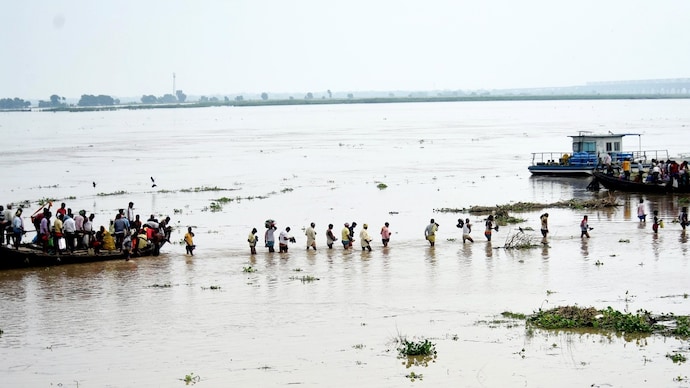
People move to safer places as Ganga river overflows near Patna (Photo: PTI)
The monsoon has plunged parts of India into a familiar crisis: rising water levels inundating large parts of Uttar Pradesh, Uttarakhand, Assam and Bihar. Of these, Bihar is bearing some of the most severe flood conditions. So far, torrential rain has reportedly affected at least 17 lakh people in 10 districts of Bihar.
Heavy rainfall in various districts, including Bhojpur, Patna, Bhagalpur, Vaishali, Lakhisarai, Saran, Munger, Khagaria, Supaul and Begusarai caused rivers and streams to overflow.
In Bhagalpur district of Bihar, six blocks — Kursela, Barari, Manihari, Amdabad, Mansahi, and Pranpur — are severely affected, with nearly five lakh people reportedly living with floodwaters at their doorsteps.
The water level at Bhagalpur station reached 34.86 metres, matching the high flood level and well above the danger mark of 33.68 metres on August 13. Nearby stations like Kahalgaon and Ekchari are also in critical condition, according to Central Water Commission (CWC) data.
India Today’s OSINT team analysed recent flood data from the CWC alongside remote sensing imagery to assess the flood situation across India. The Ganga in Uttar Pradesh, the Ghagra in Bihar, the Ichamati in West Bengal, and the Brahmaputra in Assam are all flowing above danger levels. Ichamati River in West Bengal has breached danger marks in two locations.
An analysis of Sentinel-2 satellite data has produced precise flood maps of Bihar, identifying affected locations along the Ganga and other rivers that have risen above danger levels across the state.
Sentinel-2 imagery shows the Ganga near Bhagalpur overflowing into Akbarnagar, Tilakpur, and Belthu, inundating roughly 19 kilometres and breaching its embankments.
Flood mapping of Bihar’s Chandan region and Jharkhand’s Ichagarh area reveals vast stretches of land submerged under water.
In Jharkhand’s Sahibganj district, around 20,000 people in five blocks are reportedly affected as the Ganga crosses the danger mark, flooding homes. Since June 17, the state has received 40% above-normal rainfall, as per IMD.
The Teesta in Sikkim and West Bengal, the Yamuna in Uttar Pradesh, and Bihar’s Chandan river are flowing at high levels, as per CWC data. The IMD has issued red alerts for Sikkim, Assam, and Meghalaya, and orange alerts for Bihar, Himachal Pradesh, and Arunachal Pradesh.
- Ends
Published On:
Aug 13, 2025


.png)
.png)
.png)


 14 hours ago
3


 English (US) ·