
.png)
.png)
.png)
.png)


 2 hours ago
4
2 hours ago
4
ARTICLE AD BOX
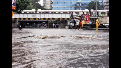
Mumbai: Mumbai recorded over 500 mm of rainfall in just 84 hours between 8.30 am on Aug 15 and 8.30 pm on Aug 18, with the ongoing wet spell causing havoc on Monday morning—the first working day of the week—and prompting the India Meteorological Department (IMD) to issue a red alert for Aug 18 and 19, the first such alert for the city this season.While extremely heavy showers began lashing the city in the early hours of Saturday (it was a holiday), the intensity slightly reduced on Sunday but again escalated on Monday. Cumulative rainfall data shows that since Aug 15, Mumbai recorded over 500 mm: 244 mm between Aug 15-16, 83.8 mm between Aug 16 and 17, 99.4 mm between Aug 17 and 18, and 129.1 mm on Aug 18 (8.30 am to 8.30 pm).
Mumbai Rain Havoc: Red Alert Issued As Maximum City Struggles With Waterlogging, Traffic Chaos
Several areas in the city recorded more than 100 mm rainfall in just eight hours till 2 pm on Monday.
Chembur received the highest at 177 mm, followed by Dadar (173.4 mm), Worli (170.2 mm) and Wadala (165 mm). Other high-rainfall pockets included Versova (149.4 mm), Vikhroli West (145.8 mm), Bandra West (145 mm), Khar (131 mm) and Bandra Kurla Complex (127.2 mm).The IMD has cautioned that widespread heavy rainfall activity across Maharashtra, including Mumbai, is very likely to continue until Aug 21.IMD Mumbai chief Shubhangi Bhute said the low-pressure area over the Bay of Bengal, along with the associated cyclonic circulation and east–west shear zone, is expected to bring heavy to very heavy rainfall across the Konkan region.
"For Aug 18, a red alert was issued for Mumbai, Thane, Raigad and Ratnagiri, excluding Palghar and Sindhudurg. A red alert has also been issued for Mumbai and Thane on Aug 19. In addition, a fisherman warning has been issued," she said.The IMD warning for fisherfolk read, "Squally weather with wind speeds of 45–55 kmph, gusting up to 65 kmph, is expected along and off the North Konkan coast and adjoining sea areas from Aug 18 to 22, 2025.
Fishermen have been advised to avoid venturing into these areas during this period."Meanwhile, the intensity of rain is likely to ease only from Aug 21, when a yellow alert has been forecast indicating heat rainfall at isolated places.While the intensity of rain on Monday was slightly lower than the deluge of Aug 16—when Marol (207 mm), Santacruz (202 mm) and Vikhroli (196 mm, where a landslide claimed two lives) were inundated—the impact was far greater as the downpour struck during daytime, catching students on their way to school and office-goers at the start of the week.A few independent weather experts said that the most critical development was expected on Aug 18 with the likely formation of an induced vortex around the Palghar region, which has prompted issuance of a red alert by the IMD for the area due to the potential for extremely heavy rainfall.


 English (US) ·