ARTICLE AD BOX
Last Updated:October 27, 2025, 11:07 IST
Cyclone Montha: IMD has forecast intense rain for Andhra Pradesh as the cyclone nears landfall, while the Meteorological Dept has issued precautionary alerts for Tamil Nadu

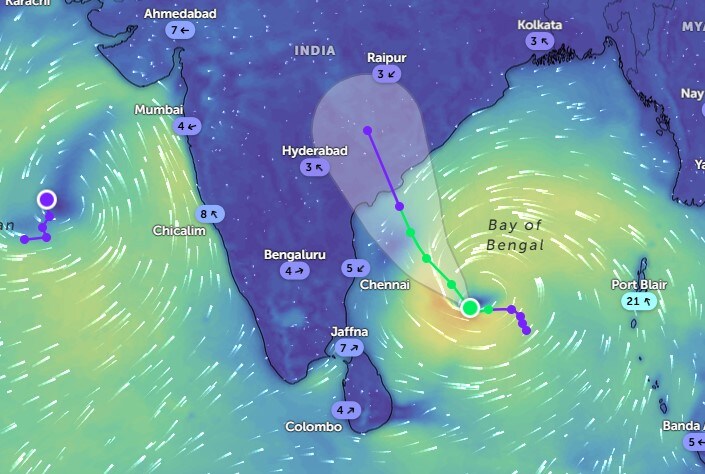
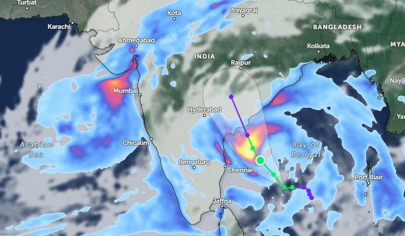
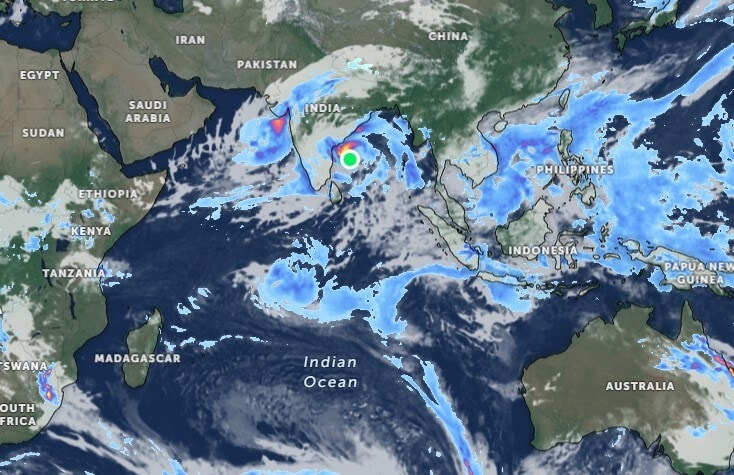
Cyclone Montha, brewing over the Bay of Bengal, is set to bring heavy rainfall across parts of Andhra Pradesh, while Telangana will experience cloudy skies and moderate showers. The India Meteorological Department (IMD) has also placed Tamil Nadu on alert, warning of very heavy rain in isolated districts as the cyclone moves closer to the east coast.

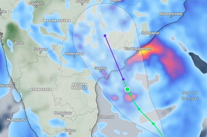
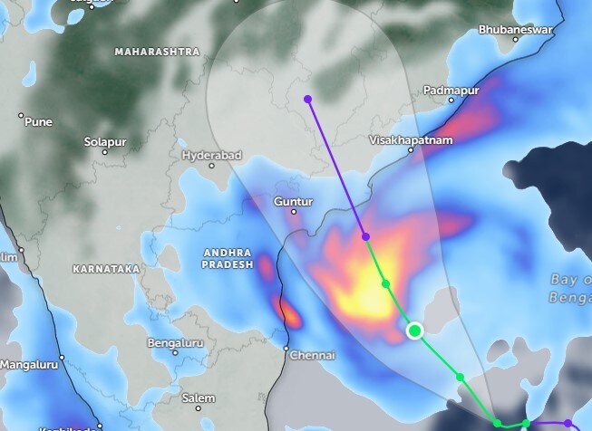
Cyclone Montha is currently positioned about 550 km off the Andhra Pradesh coast. The system’s vortex is moving at a speed of 75 km per hour and is expected to make landfall near Visakhapatnam at around 2:30 am on October 29. Wind speeds are likely to remain around 75 kmph at the time of landfall. Though not classified as an extremely severe system, officials have urged the public to remain cautious and alert.

According to the IMD, light to moderate rainfall is expected across several parts of Coastal Andhra Pradesh and Yanam from October 27 to 30, in Rayalaseema on October 28 and 29, and in Telangana from October 28 to 30. Heavy rainfall is likely in some areas, while very heavy rainfall has been forecast for Rayalaseema on October 27 and 28, Coastal Andhra and Yanam from October 27 to 29, and Telangana on October 28 and 29.

The IMD has further warned of extremely heavy rainfall exceeding 21 cm at isolated locations in Coastal Andhra, Yanam, and Telangana on October 28. Gusty winds of 30-40 kmph are expected to persist until October 30.
")
Despite the cyclone’s proximity, Telangana is unlikely to experience significant rainfall on Monday. The sky will remain cloudy, with scattered showers expected until 9 pm. Moderate rainfall will begin in areas along the Andhra-Telangana border thereafter and continue through Tuesday, bringing heavy rain across Telangana. Daytime weather is expected to remain pleasant for travellers on October 27.

In Andhra Pradesh, heavy to very heavy rainfall is forecast. Showers are likely to begin after 10 am. in East Rayalaseema and gradually spread across the region. By noon, moderate rain will cover much of Rayalaseema, extending to coastal areas by 1 pm. Rainfall intensity is expected to increase after 5 pm, covering North Andhra as well. Widespread rain will likely continue across the state until late night, with heavy spells in some locations.
Meanwhile, a trough over the Arabian Sea is moving towards Gujarat and could intensify into a cyclone. This rare situation, with two strong cyclonic systems developing simultaneously in the Bay of Bengal and the Arabian Sea, has made regional weather conditions highly active. A new low-pressure area is also likely to form over the Indian Ocean on Tuesday, potentially bringing additional rainfall.
Temperatures are expected to range between 30-31°C in Telangana and 27-30°C in Andhra Pradesh. Daytime humidity will be around 56% in Telangana and 80% in Andhra Pradesh, rising to 89% and 94% respectively at night. The overall weather pattern indicates increasing rainfall activity, particularly across Andhra Pradesh from this afternoon onwards.
Meteorologists have cautioned that this wet spell could continue into November. New cloud formations are moving north from Antarctica towards the equator, where interactions between cold and warm air masses could generate additional troughs and low-pressure systems. Consequently, intermittent moderate rainfall may persist through next month, and farmers have been advised to remain vigilant.
In Tamil Nadu, the IMD has issued an orange alert for Chennai, Tiruvallur, Kanchipuram, and Ranipet districts today, warning of very heavy rainfall accompanied by thunder and lightning. A yellow warning for heavy rain has also been issued for Chennai, Kanchipuram, Chengalpattu, and Ranipet tomorrow. The sky is expected to remain generally cloudy over Chennai and its suburbs, with heavy downpours likely in isolated areas.
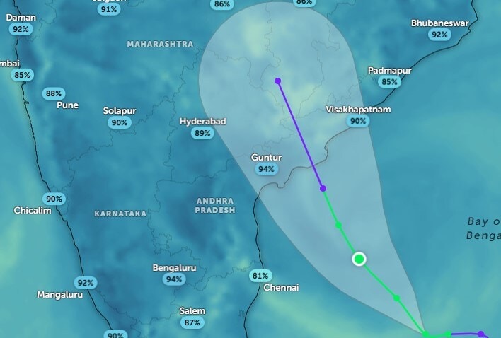
Cyclone Montha is currently located around 600 km east–southeast of Chennai, moving towards Andhra Pradesh at a speed of about 16 kmph. The IMD predicts that it will intensify into a severe cyclonic storm later today and cross the coast of Andhra Pradesh near Kakinada, between Machilipatnam and Kalingapatnam, tomorrow evening or night, bringing maximum sustained winds of up to 110 kmph at landfall.
While a cyclone warning has been issued for Andhra Pradesh and Yanam, the IMD has clarified that Tamil Nadu will not experience significant impact. Cyclone Warning No. 2 has been issued for 9 ports, Chennai, Cuddalore, Nagapattinam, Ennore, Kattupalli, Puducherry, Karaikal, Pamban, and Thoothukudi, as a precautionary measure.
News Photogallery india Cyclone Montha: Rainfall Prediction For Andhra Pradesh, Telangana, Tamil Nadu Till October 29


 English (US) ·