ARTICLE AD BOX

NEW DELHI: The road transport ministry has made it mandatory to include a dedicated analysis based on datasets from the National Database for Emergency Management (NDEM) in the preparation of all highway project reports.
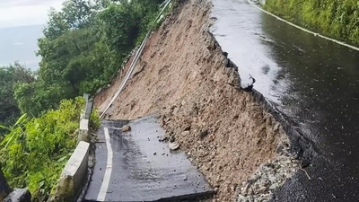
This decision comes amid increasing instances of roads, particularly in hilly areas, being washed away due to heavy rain and landslides.NDEM has been developed and maintained by the National Remote Sensing Centre (NRSC) and Indian Space Research Organisation (ISRO), and the portal serves as a comprehensive geospatial platform for disaster management, risk assessment, and infrastructure planning. It hosts multi-temporal satellite data, thematic layers, and decision support tools for monitoring natural hazards such as floods, landslides, droughts, and cyclones.In a communication to all states and highway agencies, the ministry has said the dedicated analysis based on NDEM datasets must include use of floodplain, digital elevation models (DEMs) and land use layers to identify optimal alignment to minimise exposure to natural hazards while deciding alignments. These must integrate flood extent and river basin layers to plan adequate cross-drainage structures and prevent future inundation issues, and landside risk mapping in case of hill roads.
“All alignment approval proposals to be placed before the different committees shall invariably indicate if the analysis on NDEM has been carried out and to place the results of the analysis for consideration of the committee,” the ministry said.Separately, the ministry has also directed that while preparing project reports for highway projects in hilly areas, topographical surveys should be carried out for a 300-metre-wide strip.
It said the base plan prepared using topographical data should be superimposed with the Indian Landslide Susceptibility Map. “The landslide inventory of past incidents should be collected and studied. Further, slope movement (in mm/year) should be analysed from DEMs using InSAR or similar satellite imagery and historical data available through online resources developed by the National Remote Sensing Agency,” the ministry added.The ministry stated that additional land should be acquired at culvert and structure locations to channelise hillside streams for the construction of catch-water drains, enabling effective interception and disposal of runoff that can cause erosion, slope instability, and pavement deterioration.To address the issue of identifying dump sites for muck disposal, it said that for new roads, the preferred approach is to design them in such a way that excavated material can be fully utilised in constructing embankments and fill slopes within a short distance from the source location.

 1 hour ago
4


 English (US) ·