 48 minutes ago
7
48 minutes ago
7
ARTICLE AD BOX
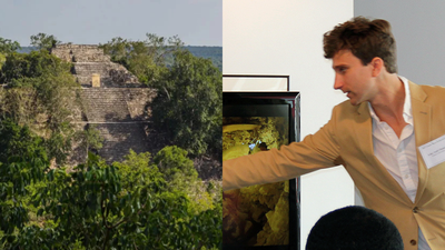
Most major archaeological discoveries begin with years of fieldwork, expensive expeditions and painstaking excavation. The discovery of Valeriana, a vast ancient Maya city hidden beneath the forests of southern Mexico, began very differently.
Luke Auld-Thomas, a PhD student at Tulane University, was searching online when he came across an obscure LiDAR dataset buried deep in Google's search results.
What appeared to be routine environmental survey data turned out to contain evidence of one of the largest Maya urban centres ever identified. The finding has revealed a lost city, challenged long-held assumptions about the Maya world and demonstrated how modern archaeology increasingly depends on digital data as much as traditional excavation.
The Google search that led a lost Maya city
While researching ancient Maya settlements during his PhD studies in 2023, Luke Auld-Thomas came across a LiDAR survey produced by a Mexican environmental monitoring organisation. He later recalled finding the dataset while scrolling through something like page 16 of Google search results.The survey had been collected for environmental purposes rather than archaeology. For years, the data remained publicly available online without attracting significant attention from researchers studying the region's ancient past.
Auld-Thomas downloaded the files and began analysing the information. What emerged was not simply a collection of isolated structures but the outline of a large and densely populated urban landscape hidden beneath the forest canopy.The findings were later published in 2024, revealing the lost Maya city now known as Valeriana and highlighting the archaeological potential of overlooked digital datasets.
The ancient city hidden beneath the jungle
The newly identified city was named Valeriana after a nearby lagoon in the Mexican state of Campeche.Researchers identified thousands of structures spread across the landscape, including pyramids, plazas, residential complexes, reservoirs, causeways and a ball court. These features indicate that Valeriana was not a minor settlement but a significant political and ceremonial centre.The city appears to have flourished during the Late Classic period of Maya civilisation between roughly AD 750 and 850.Population estimates suggest that between 30,000 and 50,000 people may have lived there during its peak.
That would make Valeriana one of the most densely populated Maya urban centres known to archaeologists and larger than many communities in the region today.The scale of the site surprised researchers because it had remained undocumented despite being located in an area that is not especially remote.
The technology that revealed what the eye could not see
Valeriana was identified using LiDAR, short for Light Detection and Ranging.The technology works by firing millions of laser pulses from aircraft toward the ground.
While vegetation reflects many of the pulses, some pass through gaps in the canopy and reach the surface below. Researchers can then digitally remove the vegetation layer and generate detailed maps of the landscape.In heavily forested regions, LiDAR has transformed archaeological research.Dense vegetation often conceals ancient structures that are difficult or impossible to identify from the ground. LiDAR allows researchers to examine vast areas and reveal roads, terraces, buildings and urban layouts hidden beneath forests.When the forest canopy was digitally stripped away from the Campeche dataset, the outlines of a large Maya city became visible.Valeriana joins a growing list of major archaeological discoveries made possible through this technology.
A city hidden in plain sight
Valeriana lies relatively close to modern infrastructure and not far from roads used today.Despite this proximity, the dense tropical forest concealed the city's true scale for centuries.
From ground level, the landscape appears largely natural. The LiDAR data revealed a very different picture.The discovery highlights how much of the ancient Maya world remains hidden beneath vegetation across southern Mexico and Central America.Researchers have increasingly found that landscapes once considered sparsely populated actually contain extensive evidence of human settlement. Roads, agricultural terraces, water-management systems and urban centres are appearing across areas previously thought to be largely undeveloped.Valeriana is among the clearest examples of how forest cover can conceal entire cities from view.
The significance of the discovery
For decades, scholars debated the size and density of Maya populations living in tropical rainforest environments. Earlier interpretations often portrayed many Maya centres as isolated ceremonial sites surrounded by relatively empty landscapes.Recent discoveries have challenged that view.Valeriana adds to a growing body of evidence showing that large populations lived in highly organised urban environments connected by transportation networks and supported by sophisticated infrastructure.The city appears to have been part of a broader landscape shaped extensively by human activity. Its discovery strengthens the argument that ancient Maya societies managed their environments on a much larger scale than previously understood.
More than a lucky click
The viral version of the story often focuses on the Google search itself. The reality is more complex.Finding the dataset was only the beginning.Auld-Thomas and his colleagues spent months analysing the LiDAR imagery, comparing patterns with known Maya sites and evaluating whether the features represented a genuine urban settlement.
The identification of Valeriana required archaeological expertise, technological analysis and collaboration between researchers.The discovery reflects a broader shift taking place within archaeology. Increasingly, researchers are combining traditional fieldwork with advanced mapping technologies and digital archives.Some of the most important discoveries now begin on computer screens long before archaeologists set foot in the field.
How many more cities are still waiting to be found?
Researchers believe only a fraction of the Maya world has been mapped using high-resolution LiDAR.Large areas of southern Mexico, Guatemala, Belize and neighbouring regions remain poorly surveyed. As more data becomes available and older datasets are re-examined, archaeologists expect additional discoveries.The Valeriana finding demonstrates that significant archaeological sites can remain unnoticed even when the data already exists.Future discoveries may come from new aerial surveys, but they may also emerge from forgotten databases, overlooked archives and publicly available information that has never been examined through an archaeological lens.


 English (US) ·