
.png)
.png)
.png)
.png)


 19 hours ago
2
19 hours ago
2
ARTICLE AD BOX
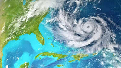
Hurricane Erin 2025 has moved up the ladder and quickly become a powerful Category 5 storm, marking the first major hurricane of the 2025 Atlantic season. It now has sustained winds of 160 mph (260 km/h) and is moving through the northeast Caribbean, creating large ocean waves and heavy rainfall.
Hurricane Erin 2025: Rapid growth and current status
Hurricane Erin first started as a tropical wave off West Africa, classified as a tropical storm just last week, on August 11, before undergoing explosive intensification. In less than 25 hours, from early August 15 to the morning of August 16, it escalated from a weak hurricane to a Category 5 storm with winds soaring to 160 mph, which is a rare and dangerous speed of strengthening.This makes Erin the earliest Category 5 hurricane ever observed in the open Atlantic and one of the fastest-intensifying storms on record.The storm is currently located to the northeast of Anguilla and Puerto Rico, moving in a west-northwest direction, and is expected to move northward early next week. The storm’s center is projected to remain offshore, avoiding direct landfall on the US mainland.
Which US states are at risk?
Even if Hurricane Erin 2025 doesn’t make landfall in the United States of America, it still poses significant threats to parts of the East Coast:The Outer Banks in North Carolina are especially at risk because of their unique shape, which makes them vulnerable to strong surf, dangerous rip currents, and possible coastal flooding.
Long Island, New York, has a prominent coastline and could experience stronger wave action and storm surge, even if the storm stays offshore.Cape Cod, Massachusetts, has a jutting shape, making it prone to powerful surf and possible flooding.The Mid-Atlantic and Northern New England coasts, while less exposed than the areas mentioned above, may still see rising swells and potential flooding.Forecasters have warned that Hurricane Erin’s outer bands could lead to life-threatening surf, rip currents, and possible beach erosion along the entire East Coast, from Florida to Maine, in the coming days.
Impact in the Caribbean
Hurricane Erin 2025 is already affecting several Caribbean islands with heavy rain, flash flooding, landslides, and mudslides, particularly in the Leeward Islands, the US Virgin Islands, Puerto Rico, Hispaniola, and Turks and Caicos. Tropical storm watches are in effect in these regions.
Emergency actions are already being taken, including the deployment of over 200 FEMA personnel to Puerto Rico, the preparation of shelters, and the closure of ports in Puerto Rico and the US Virgin Islands.In Cape Verde, where the storm first formed, intense rainfall has already caused nine deaths and triggered disaster declarations.
Important safety tips
Residents living in areas at risk should take the following steps to stay safe:Stay informed: Keep track of updates from the National Hurricane Center and local authorities regarding watches, warnings, and evacuation notices.Avoid coastal waters: Do not swim or go near the beach. Even without direct landfall, strong swells and rip currents can be very dangerous.Know your evacuation route: Those living in low-lying or flood-prone areas, such as the Outer Banks, should be ready to evacuate quickly and safely.Secure your home: Close windows and doors, and secure any loose outdoor objects that could become airborne in high winds.Prepare an emergency kit ready to go: Include items such as water, non-perishable food, a flashlight, first-aid supplies, medications, and emergency contact information.Avoid flooded roads: These roads may have hidden hazards and should not be driven on until officials declare them safe.Follow local instructions: If local authorities order an evacuation, leave immediately. Do not dismiss the risk based on how far you are from the storm’s predicted path.The rapid intensification of Hurricane Erin 2025 is a testament to the growing concerns about how climate change is affecting the frequency and strength of hurricanes.
Warmer ocean temperatures, lower wind shear, and increased moisture in the air have contributed to more frequent and rapidly intensifying storms, making it harder to predict and prepare for these events.However, during these times of natural disasters and uncertainty, prioritize safety measures and stay alert at all times. When you’re at home, make sure to secure your living space, as well as check on your neighbors, especially the vulnerable individuals like the elderly, children, and the disabled. If you’re planning to step out, wait for the official ‘all-clear’ message. At all times, be cautious, avoid downed power lines, report hazards, and follow local instructions.
Havana residents face blackouts after hurricane Ian


 English (US) ·