 4 hours ago
5
4 hours ago
5
ARTICLE AD BOX

A series of weather systems brewing over land and sea are set to bring a dynamic mix of heavy rainfall, thunderstorms, and cooler temperatures across several parts of India this week.
From the southern tip of Tamil Nadu to the misty hills of the Western Ghats and the coasts of Andhra Pradesh, widespread rainfall and thunderstorm activity are expected to dominate much of the subcontinent’s southern and eastern regions, while a drop in temperatures will finally usher in the season’s chill across northern India.According to the latest meteorological analysis issued at 9:04 pm IST on October 22, 2025, multiple active weather systems are influencing India’s atmospheric conditions, leading to varied weather phenomena from heavy rains and gusty winds to fog and falling temperatures.Heavy rains lash the south peninsulaThe India Meteorological Department (IMD) forecast light to moderate rainfall or thunderstorms at many places, accompanied by isolated heavy to very heavy spells over several regions. Tamil Nadu, Kerala, Coastal and south interior Karnataka, Andhra Pradesh, Telangana, and Rayalaseema are bracing for intense rain through the week, with particularly heavy rainfall episodes till October 28.
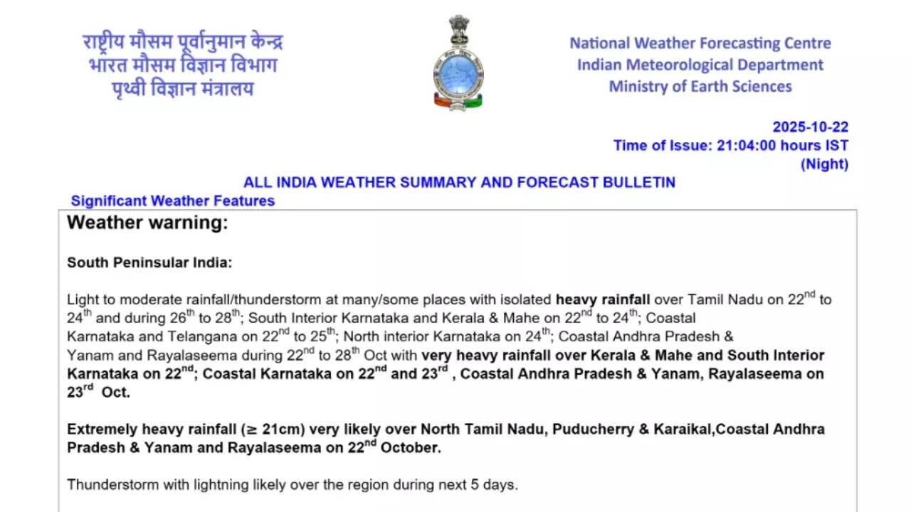
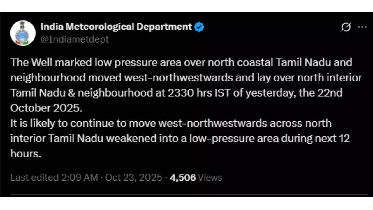
Tamil Nadu, Puducherry, and Karaikal are witnessing some of the most intense rainfall activity, with extremely heavy rain, precipitation exceeding 21 cm in a day. The well-marked low-pressure area over the southwest Bay of Bengal, now located over north coastal Tamil Nadu after crossing the coast, is a major contributor to this deluge. It is expected to move west-northwestward and gradually weaken over the next 24 hours.Coastal Karnataka, Kerala, and parts of South Interior Karnataka are also under similar warnings, with very heavy rainfall predicted for October 23. In Kerala and Mahe, extremely heavy downpours have already led to concerns over localised flooding and the potential for landslides in hilly terrain. Residents and travellers are advised to remain cautious and to avoid any unnecessary travel, and be prepared for any emergencies.
The IMD has further highlighted that thunderstorms accompanied by lightning are likely to persist over the entire southern region for the next five days.Flash flood risks and impactsGiven the intensity of rainfall, the IMD has issued flash flood warnings for several districts in Kerala, Tamil Nadu, and Andhra Pradesh. Areas at low to moderate risk include Alappuzha, Ernakulam, Idukki, Kollam, and Kottayam in Kerala, and adjoining regions of Tamil Nadu such as Dindigul, Kanyakumari, Theni, Tirunelveli, and Virudhunagar.
Coastal Andhra Pradesh districts including Guntur, Prakasam, and Nellore, along with Rayalaseema’s Chittoor and Kurnool, are also on alert.The forecast warns of possible surface runoff and inundation in low-lying areas due to already saturated soil conditions, with urban flooding and waterlogging expected in cities. Minor structural damage, road blockages, and disruption to local transport networks could also occur, so residents are advised to be prepared for any emergencies.
In addition, localised landslides and mudslides are possible in the Western Ghats and adjoining hill regions.
Do not travel if not necessary.
The Andaman & Nicobar Islands are also expected to experience light to moderate rain and thunderstorms at many places, with isolated heavy rainfall predicted between October 23 and 27. The region will also face thunderstorms accompanied by lightning and gusty winds ranging from 30–40 kmph over the next seven days.Eastern and central India: Stormy skies and fogWhile southern India deals with torrential rains, parts of east and central India are also under the influence of active weather systems. Odisha is expected to witness thunderstorms and lightning till October 26, along with pockets of dense fog during the early hours of October 23. Similar thunderstorm activity is likely over Madhya Pradesh, Vidarbha, and Chhattisgarh for the next five days, posing hazards for outdoor activities and local air travel.Western India: Isolated downpours for the coastIn western India, weather activity will be more localised but still significant. Light to moderate rain or thunderstorms are forecast over many places in Konkan, Goa and parts of central Maharashtra, with isolated heavy rainfall predicted for October 23. The monsoon’s retreating phase is expected to bring sporadic lightning and thunderstorm activity across the western coastal belt during the next five days.Northern India: A fall in temperaturesWhile most of the country remains under the influence of rain-bearing systems, the north is beginning to feel the first real signs of post-monsoon transition. A fall in minimum temperatures by 2–4 degrees Celsius is forecast across most parts of Northwest India over the next 2–3 days, marking the arrival of early winter conditions.Daily forecast overviewOctober 23 will see rainfall activity expanding westward to include Konkan, Goa and parts of central Maharashtra, while the Andaman & Nicobar Islands will begin their wet spell. The pattern of heavy rainfall continues through October 24–26, gradually tapering off toward the end of the week but persisting in Andhra Pradesh and the Andaman region until October 28.


 English (US) ·