

.png)
.png)
.png)
.png)


 2 hours ago
3
2 hours ago
3
ARTICLE AD BOX
The Kedarnath Yatra in Uttarakhand has been temporarily suspended for three days following a red alert issued by the India Meteorological Department (IMD) predicting heavy rainfall across the region, as per the ANI reports.
As per the predictions by the IMD, heavy rain warning will remain in place for August 12, 13, and 14, with significant downpours expected in Rudraprayag district and other parts of the state.More than 23 roads, including four key routes, have been shut in Uttarakhand’s Pithoragarh district following landslides, report added.District Magistrate Prateek Jain confirmed that the administration has been placed on high alert and extensive security arrangements are in place to ensure the safety of both pilgrims and residents.
“As per the predictions by the IMD, red and orange alerts have been predicted in Rudraprayag and other districts of the state. The administration has been put on alert and security arrangements have also been made,” he said in a video statement.
Jain appealed to residents living near water bodies to move to safer locations, adding that river water levels are being closely monitored. “We are keeping a check on the rising water levels of the river here.
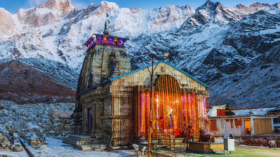
We also appeal to residents to shift to safer places and be safe. All personnel, including the police, public works department and disaster management teams, have been asked to be on alert. We will be keeping a check on the weather, and will let the public know when the Kedarnath Yatra will resume,” he added.The Kedarnath temple, dedicated to Lord Shiva, stands at an altitude of over 11,000 ft in the Himalayas and draws thousands of devotees each year.
The temple doors for the 2025 Yatra season opened on May 2.Read more: From Gokarna to Varkala — 8 beautiful coastal towns of India that are a must-visit in this lifetimeThe IMD’s red alert extends to several districts, including Haridwar, Dehradun, Tehri, Pauri, Nainital, and others. Authorities have urged residents and travellers to exercise caution and plan journeys according to weather updates.In addition to Uttarakhand, other states are also grappling with intense monsoon activity. The IMD has forecast thunderstorms with rain for Tuesday in parts of North India, with maximum and minimum temperatures in Delhi expected at 34°C and 25°C respectively.
Cloudy skies, occasional hazy sunshine, and high humidity are likely to persist, while early morning showers have caused waterlogging in several low-lying areas, including Rao Tularam Marg.
Similar conditions with cloudy skies and intermittent rainfall are expected over the next few days.Read more: 7 impressive monuments in North India that tell timeless storiesHimachal Pradesh continues to experience severe monsoon impacts, with over 229 deaths reported since June 20 due to rain-related incidents and road accidents.
According to the State Disaster Management Authority (SDMA), losses to infrastructure, agriculture, and livestock have exceeded INR 2,000 crore. Relief operations are still ongoing, but they are hindered by subsequent landslides and road blockages and residents have been asked to stay alert as heavy to very heavy rainfall is expected over the next few days.Meanwhile, Bihar will witness a spike in the rainfall activity around August 12 and 13 as very heavy showers along with lightning strikes are likely over North Bihar (19 districts).
South Bihar may also receive scattered heavy showers.Meanwhile, the Regional Meteorological Centre (RMC) in Kolkata has forecast that South Bengal districts might witness scattered rain and thunderstorms until Thursday, while heavy rainfall will continue in North Bengal.The situation across these regions indicates that there is a likelihood of widespread impact of the current monsoon phase, whereas authorities are making every effort to take action when required, and urging the public to follow official advisories and take precautions to stay safe.


 English (US) ·