 3 hours ago
5
3 hours ago
5
ARTICLE AD BOX
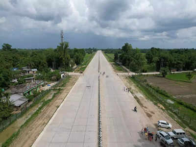
NEW DELHI: The National Highways Authority of India (NHAI) has started putting details of land acquisition status and statutory clearances for each highway project — tenders of which are out or will be floated — online.
This is aimed at bringing greater transparency, and reducing disputes and arbitrations after projects are bid out.The exercise began on Wednesday and the dynamic status of conditions to be fulfilled before every project will now be updated regularly, allowing bidders to have a clear understanding of project readiness before placing bids, a senior NHAI official said. “This will also put pressure on us, as an authority, to fulfil our obligations, which are crucial for project execution.
It will also ensure a level playing field for contractors,” the official added.TOI has learnt that the authority has made data such as land acquisition details, environmental approvals, and forest, wildlife, railway and waterway clearances — mandatory for project execution — available for each project.In the last Parliament session, the road transport ministry had informed Rajya Sabha that 489 NH projects, originally slated for completion by March 2025, were running behind schedule due to delays in land acquisition, forest and wildlife clearances, and railway approvals.
“Such delays result in time and cost overrun, and disputes. The only way to avoid disputes and arbitrations is to ensure that authorities meet all the conditions precedent for start of construction. Once this is done, default on the part of contractors can be dealt with easily as there will be no scope for counter charges,” said a senior official.In another decision, the NHAI announced deployment of network survey vehicles (NSVs) in 23 states, covering 20,933 km of NHs, to gather detailed road inventory and pavement condition data, such as surface cracking, potholes and patches, so that corrective maintenance can be carried out expeditiously.A 3D laser-based NSV system is capable of capturing and reporting road defects automatically without human intervention with the help of high-resolution 360-degree cameras, differential GPS, inertial measurement units, and distance-measuring indicators.


 English (US) ·