

.png)
.png)
.png)
.png)


 2 hours ago
3
2 hours ago
3
ARTICLE AD BOX
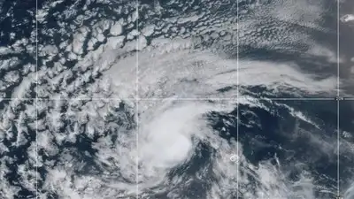
Tropical Storm Erin has formed in the eastern Atlantic and is poised to become the first hurricane of the 2025 Atlantic season. Located just west-northwest of the Cabo Verde Islands, Erin is carrying winds of around 45 mph, is moving steadily westward at 20 mph, and is now being closely monitored by meteorologists.
Although it’s still far from land, forecasters anticipate gradual strengthening, possibly into a major hurricane by later this week.
Erin’s formation and forecast: What’s happening now
Tropical Storm Erin, the fifth named storm of 2025, formed in the eastern tropical Atlantic and is expected to intensify into a hurricane by midweek. The National Hurricane Center reports it is currently about 280-430 miles west-northwest of the Cabo Verde Islands, with sustained winds of 45 mph and moving west at roughly 20-23 mph.Erin is forecast to track westward through the week before turning north-northwest between Thursday and Friday. This northward turn could keep the storm away from the Lesser Antilles and the US, though locations including Bermuda, the Bahamas, Canada’s Atlantic provinces, and even the US East Coast should monitor its path closely.Erin’s long westward track puts it far from immediate land, but in a conducive environment, characterized by warm sea surface temperatures, low wind shear, and moist air, it may become a major hurricane (Category 3+) by the weekend.
Who should be on alert?
Cabo Verde Islands: Erin’s initial impact has been most severe here. Already experiencing heavy rain and flooding from Erin’s early stages, resulting in casualties and damage. The storm brought deadly flooding and heavy rains, particularly on São Vicente, triggering a state of emergency on São Vicente and Santo Antão.Leeward Islands and Caribbean: Current projections place Erin passing north of these islands by the weekend.
While direct landfall seems unlikely, surf and squall warnings are plausible, especially if Erin intensifies rapidly. If it does, Erin could pass close enough to cause rough seas, squalls, or indirect rainfall impacts.US East Coast and Bahamas: There are no watches or warnings in effect now. Though a landfall is not expected, a powerful storm passing nearby could generate tropical-storm conditions, high surf, and heavy rain, especially in eastern North Carolina up through New England, including Long Island and Cape Cod.Bermuda, Atlantic Canada: These regions should stay alert in case the forecast track brings Erin closer into their proximity.

Why Erin matters (and what makes its path ‘uncertain’)
Erin is setting the tone for a season that NOAA projects to be above-normal, with 13-18 named storms, 5-9 hurricanes, and 2-5 major hurricanes. Ocean temperatures are unusually warm, and forecast models offer two paths: a northward bend away from populated areas or a west-northwest drift that brings concern to the Caribbean and the US.
The cone of uncertainty remains wide beyond five days, indicating that exact forecasts must remain flexible.
Essential safety measures: The to-do list
Stay informed: Regularly check updates from the National Hurricane Center (NHC) and trusted weather sources. Pay attention to alerts and advisory updates; even subtle shifts in storm track can significantly change risk profiles.Prepare early: Be steadfast about evacuation Planning. Make a list of designated shelters and safe routes for your area.
Keep an emergency kit ready to go. Stock up on essentials, like water, non-perishable food, first-aid supplies, flashlights, and important documents.Coastal safety: Monitor alerts for rip currents, especially in beach zones near but not directly impacted by Erin. If preplanned, consider postponing water recreation if seas worsen.Travel awareness: Travelers to the Caribbean, Bahamas, or East Coast should monitor potential flight delays, cancellations, or sea transport disruptions.
Cruise guests and tourism planners should stay flexible with itinerary planning.Community action: Local agencies and authorities should review emergency protocols and ensure public awareness campaigns are active. Maintain access to power and road infrastructure, and be ready to respond if Erin’s path shifts southwestward.
Missouri trans people could lose treatment access


 English (US) ·