 1 hour ago
3
1 hour ago
3
ARTICLE AD BOX
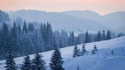
As autumn draws to a close and temperatures steadily fall, excitement is building across the United States for the first snowfall of the 2025–26 winter season. According to the latest forecasts from the National Weather Service (NWS) and the National Oceanic and Atmospheric Administration (NOAA), several northern regions are likely to experience snow earlier than usual this year.The first flakes were expected to fall over the Northern Rockies and parts of the Midwest by late September or early October, according to The Weather Channel, with snow gradually expanding eastward through November. Meanwhile, southern states are forecast to remain comparatively dry, setting the stage for a season marked by regional contrasts.
Early snowfall to blanket the Rockies and spread east by November
According to NOAA’s early projections, the first measurable snow could appear in parts of the Northern Rockies as soon as late September.
Areas across Montana, Wyoming, and Colorado may see snow on higher elevations, while accumulation at lower altitudes is likely in early October.From there, snowfall is expected to spread across the Upper Midwest, reaching states such as North Dakota, Minnesota, and Wisconsin by late October. The Great Lakes and the Northeast could experience their first significant snow by early November, following the seasonal cold fronts that sweep across the central United States.
Meteorologists note that early-season snow in mountainous areas helps establish the winter snowpack, which is vital for water resources in spring and summer.
However, it also signals an early start to challenging travel conditions in parts of the northern and central plains.
Timeline reveals when different US regions will see their first snowfall
Based on data from the NOAA Climate Prediction Center, the expected timeline for the first flakes across major US regions is as follows:Cities such as Buffalo (New York), Minneapolis (Minnesota), Bismarck (North Dakota), and Anchorage (Alaska) are predicted to be among the first to see substantial snowfall.
By contrast, southern cities like Dallas, Atlanta, and Birmingham are unlikely to see measurable snow until late December, if at all. Further regional snowfall averages can be found in the NWS first snowfall database.
NOAA winter outlook predicts contrasting conditions across the United States
The NOAA Winter Outlook (December 2025 – February 2026) paints a diverse picture of the months ahead. The Pacific Northwest, Northern Rockies, and Great Lakes are projected to experience above-average precipitation, suggesting frequent snowstorms and prolonged cold spells.
Conversely, the southern half of the United States, including Texas, the Southeast, and the Mid-Atlantic coast, is expected to be drier than normal.Meteorologists caution that while these forecasts offer a general overview, actual snowfall totals will depend on short-term weather systems that evolve during the season. Several strong storm systems may develop across the Central and Eastern United States, some of which could strengthen into nor’easters, powerful coastal storms capable of bringing heavy snow, strong winds, and hazardous travel conditions to the Northeast.
Colder and snowier winter expected as La Niña influences US weather patterns
Experts anticipate that the 2025–26 winter will be both colder and snowier than recent years, particularly in the Midwest and Northeast. Early storms could arrive by late November, accompanied by widespread ice and snow.NOAA scientists highlight the significant role of global climate patterns, especially the El Niño–Southern Oscillation (ENSO). If ENSO transitions toward a La Niña phase, it could draw cold Arctic air deeper into the United States, increasing the likelihood of heavy snowfall in northern regions.
Updates on ENSO trends can be tracked through NOAA’s ENSO Diagnostic Discussion. According to NOAA meteorologist David Novak, “Colder-than-average conditions are expected to dominate much of the Midwest and Northern states, with increased storm activity through December and January.
”
NWS urges preparedness as early snow and changing winter patterns pose risks
With early snowfall forecast in several areas, the National Weather Service is urging Americans to prepare for potential disruptions.
Snow and ice can create dangerous driving conditions, flight delays, and visibility problems, especially during the first major storms of the season. Residents are advised to check antifreeze levels, tyres, and heating systems, and to keep emergency kits in their vehicles during travel.
Even light snow can reduce traction and visibility dramatically, particularly during morning commutes.Interestingly, while this winter is expected to be harsh in many regions, long-term climate data from the Environmental Protection Agency (EPA) and NOAA show that average US winter temperatures have risen by roughly 3°F since the early 1900s. Warmer air can hold more moisture, which sometimes leads to intense, localised snowstorms; a paradox where warming trends can still bring extreme winter events.The 2023–24 winter season was officially the warmest in 130 years, yet meteorologists stress that this does not rule out severe snow events, especially in lake-effect and mountainous regions prone to sudden bursts of heavy snowfall.


 English (US) ·