

.png)
.png)
.png)
.png)


 3 hours ago
5
3 hours ago
5
ARTICLE AD BOX
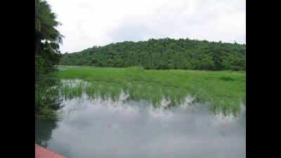
Panaji: The town and country planning department has given the greenlight to convert a 20,000 sqm land parcel on the Pilerne hillside that forms the buffer zone and catchment area for Pilerne’s Saulem Lake.
This zone change effectively reintroduces elements of the controversial Regional Plan 2011 that was scrapped after a massive public protest.The conversion was provisionally granted under Section 39A of the Town and Country Planning Act. If granted final approval, this will see a steep hill slope being opened up for construction. The land parcel is currently marked as partly orchard with ‘No Development Slope’ in the Goa Regional Plan – 2021, meaning that the gradient is considered too steep for construction and is vulnerable to soil instability.“In 2006, around the time RP-2011 was notified, over 90 trees were hacked down and the hill was burnt for days. This notification is yet another instance in the TCP’s chequered history,” said professor of development studies Solano da Silva.The TCP granted provisional approval for change of zone under Section 39A for Survey No. 37/0 and 37/1 in Pilerne on June 18. The department has given a brief window for stakeholders to voice their concerns.
Environmental experts argue that construction on such steep slopes could alter the natural water flow, exacerbating the risk of landslides.“Allowing development activities on such steep hill slopes poses a severe risk of landslides in the future. This danger extends not only to structures within the converted property but also to adjacent properties with existing structures, which could face the brunt of slope erosion and altered water flow, potentially leading to loss of life and property,” said Pilerne Citizens Forum secretary Hilario Lobo.The TCP has ignored the proximity to the eco-sensitive Saulem Lake, also known as Pilerne Lake, which was notified as a protected wetland on Dec 9 through a gazette notification.The Wetland Notification of 2018 clearly stated that a “zone of influence” means part of the catchment area of the wetland or wetland complex. The lake functions as a natural funnelled aquifer, replenished by springs.The water resources department (WRD) has demarcated the buffer zone as a water catchment area under the Catchment Area Department Authority of Goa (CADA).Environmentalists say that the TCP department has failed to independently assess the gradient and slope, with ISRO satellite imagery analysis indicating the slope is greater than 25 degrees, which should classify it as no development slope.


 English (US) ·