

.png)
.png)
.png)
.png)


 8 hours ago
5
8 hours ago
5
ARTICLE AD BOX
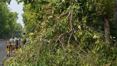
NEW DELHI: The most intense storm of the season struck Delhi early Sunday morning, with wind speeds reaching a staggering 104 kmph. Two people died in south Delhi's Bhikaji Cama Place due to electrocution after a falling branch hit a kiosk, releasing electric current.Strong winds uprooted trees across the city and toppled an 80-foot mobile tower in Safdarjung Enclave. While flight operations remained unaffected, reports of damage poured in from multiple areas. Safdarjung recorded 42 mm of rain between 2:30 am and 5:30 am, with moderate to heavy showers elsewhere.Meteorologists attributed the storm to a surge in Bay of Bengal moisture interacting with an active western disturbance.
"A cyclonic circulation over north Rajasthan, along with a trough extending eastwards, triggered the storm activity. Cloud cover continues to move toward Delhi, and thunder activity is likely to persist," said Krishna Mishra, scientist, India Meteorological Department (IMD).

Temperatures dropped sharply, bringing relief from the scorching heat. The maximum temperature at Safdarjung fell to 35.6°C—three notches below normal—compared to 41.8°C a day earlier.
The 'feel-like' temperature also dropped from 51°C to 43°C. The minimum temperature was recorded at 20°C, a dramatic eight-degree dip from the previous day.IMD has issued a yellow alert till June 19, predicting similar weather until June 21. This was the sixth thunderstorm of the season.On Monday, the maximum temperature is expected to hover around 36–38°C, with chances of light to moderate rain, thunderstorms, and gusty winds up to 60 kmph.
Tuesday may see similar temperatures.While there's no official monsoon date for Delhi yet, experts suggest it could arrive earlier than the usual June 27. The southwest monsoon has already advanced swiftly, arriving in Kerala eight days early and covering much of the peninsula and northeast by May 29. Meteorologists say active weather over Rajasthan, Madhya Pradesh and Odisha indicates a possible early onset in Delhi as well.Palam recorded 15.3 mm and Kodia Road 44.2 mm of rain early Sunday. The highest wind gust of 104 kmph was recorded at Safdarjung, followed by 67 kmph at Pragati Maidan, 63 kmph at IGNOU, and 56 kmph at Palam.The storm left a trail of disruption. In the NDMC area, 16 tree-falling incidents were reported in localities including Firoz Shah Road, BD Marg, Darbhanga Lane, Tilak Marg and Jor Bagh. Several power lines tripped due to fallen branches.In Safdarjung Enclave, a newly installed 80-foot-high tower collapsed. Residents had opposed its installation over safety concerns. "It fell around 4 a.m. Thankfully, it landed on the inner road. Had it fallen any other way, it could've caused major damage," said Rakesh Kapoor, RWA member. The tower also brought down seven electric poles, trees, a boundary wall, and a police camera pole.Meanwhile, Delhi's air quality improved, with AQI falling to 140 from 156 a day earlier—both in the ‘moderate' category. The Commission for Air Quality Management revoked Stage-I restrictions under the Graded Response Action Plan (GRAP), which had been imposed on June 7."Given the improvement in AQI and forecasts indicating continued moderate levels, the CAQM Sub-Committee on GRAP has decided to revoke Stage-I measures across the NCR with immediate effect," the panel said in a statement.


 English (US) ·