ARTICLE AD BOX
Last Updated:June 26, 2026, 16:17 IST
Twin earthquakes of magnitude 7.2 and 7.5 hit Venezuela, killing at least 235 and injuring over 4,000, with satellite images showing severe destruction in La Guaira.
![]()

Volunteers search for possible victims in a collapsed building following twin earthquakes in Caraballeda, La Guaira state, some 40 km northeast of Caracas, on June 25, 2026. (AFP photo)
Two powerful earthquakes of magnitude 7.2 and 7.5 struck Venezuela late Wednesday, leaving at least 235 people dead and more than 4,000 injured.
The back-to-back tremors triggered widespread devastation, toppling buildings, crushing rooftops and trapping residents beneath heaps of rubble as rescue teams continue search operations.
High-resolution satellite images provided by Vantor reveal the scale of destruction across La Guaira, north of Caracas, NDTV reported.
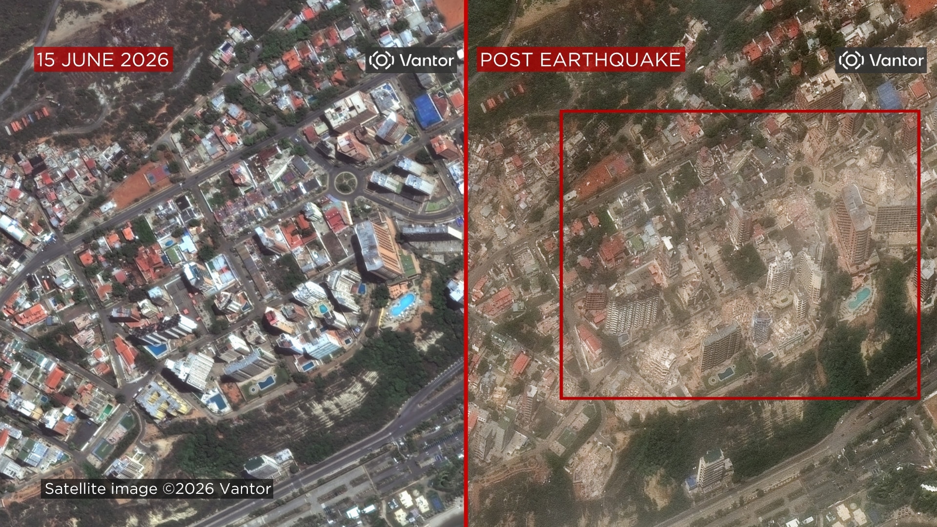
Several high-rise residential towers in the Playa Grande neighbourhood, near Simon Bolivar Airport, can be seen flattened in images captured before and after the disaster. Follow for live updates
Satellite Pics Capture Devastation
Comparisons of satellite photographs taken days apart show extensive damage to apartment complexes, commercial establishments, warehouses and industrial facilities. In Playa Grande, a once-standing white building at a road intersection appears completely collapsed, while at least five neighbouring structures have been reduced to debris. The city is blanketed in dust in post-earthquake imagery.
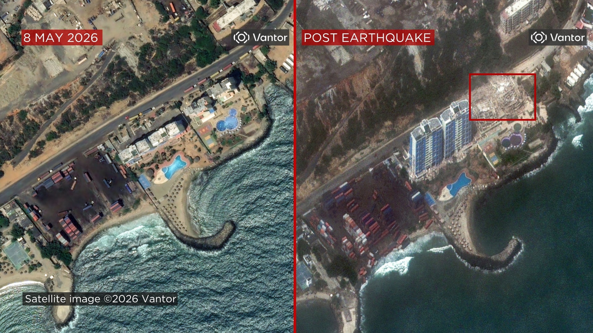
The Residencia Nautilus building and a nearby shipping container yard along Avenida La Playa also sustained heavy damage. Images from May 8 show intact structures and neatly stacked containers, whereas photographs taken on June 25 depict collapsed buildings in the vicinity.
Industrial warehouses in La Guaira were largely destroyed, leaving behind twisted steel rods and rubble. Residential blocks were also severely affected, with rows of black-roofed homes either partially collapsed or visibly tilted after the quakes.
One striking comparison between images captured on June 22 and June 25 highlights the suddenness of the disaster, showing buildings that stood only days earlier replaced by mounds of debris.
Twin Quakes Rock Venezuela
An earthquake of magnitude 7.2, centred near Moron, about 168 kilometres west of Caracas, struck first. Another, measuring 7.5, followed just 39 seconds later.
“This earthquake was the first event in a doublet, this magnitude 7.2 foreshock was followed just 39 seconds later by a larger 7.5 mainshock," the USGS said.
Strong aftershocks continued to be felt on Thursday.
Handpicked stories, in your inbox
A newsletter with the best of our journalism
About the Author
The News Desk is a team of passionate editors and writers who break and analyse the most important events unfolding in India and abroad. From live updates to exclusive reports to in-depth explainers, ...Read More
News world Flattened Buildings, Debris: Satellite Images Reveal Extent Of Venezuela Earthquakes Impact
Disclaimer: Comments reflect users’ views, not News18’s. Please keep discussions respectful and constructive. Abusive, defamatory, or illegal comments will be removed. News18 may disable any comment at its discretion. By posting, you agree to our Terms of Use and Privacy Policy.
Read More


 English (US) ·