ARTICLE AD BOX
The Forest Survey of India (FSI), the central government organisation that is responsible for the assessment and monitoring of India’s forest wealth, has stopped issuing the fortnightly alerts through which it has kept a watch on deforestation activities in near-real time for more than two years.
The data on the FSI’s Anavaran-Deforestation Alert System have not been updated since November 2025.
The portal, which has been operational since January 2024, has been using satellite data and machine learning to enable FSI to issue location alerts on the loss of forest cover to states every 15 days so that targeted field inspections can be carried out.
According to multiple sources, active monitoring through the portal was halted this January, and states stopped receiving the fortnightly deforestation alerts.
Asked why the portal had stalled, FSI joint director Shivani Dogra said Anavaran had been running only as a pilot project, and its utility was currently being assessed. “It (the portal) was never launched. We are taking feedback from the states on its utility,” Dogra said.
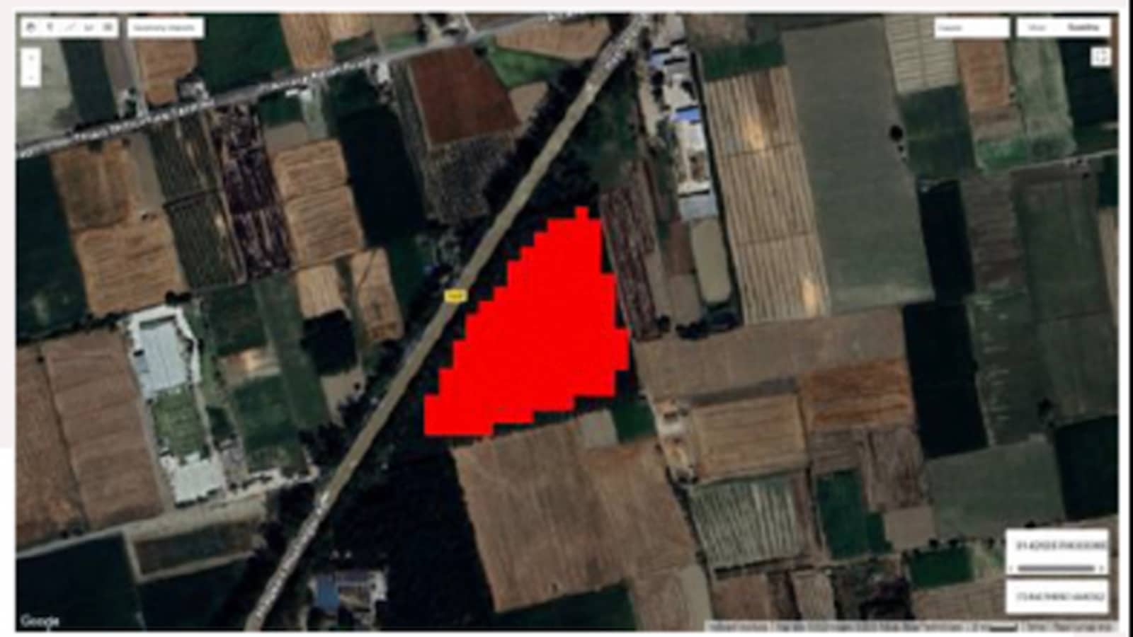 A deforestation alert for Punjab in Oct 2025. Data on Anavaran system have not been updated since November 2025.
The FSI sent 12,351 alerts at a monthly average of 561 alerts during the 22-month period from January 2024 to October 2025, Anavaran records show. The monthly average almost doubled to 1,028 alerts during the November-March period, when manmade deforestation typically peaks due to favourable weather conditions.
Sources in the Rajasthan Forest Department said the state had not received any deforestation alert after December 2025. “Like the FSI’s forest fire alert system, which has been refined over a decade, the deforestation alerts are a great example of how technology can help conservation. We hope this will only evolve for the better as a very effective tool for real-time monitoring,” a senior forest official in Jaipur said.
Story continues below this ad
A forest officer in Madhya Pradesh described Anavaran as a “logical breakthrough in tapping the full potential” of satellite data.
“We can make the best use of information through machine learning and manual confirmation. If not FSI, states too can develop the capacity for such real-time monitoring,” he said.
While publicly available Anavaran data do not quantify the area of deforestation, records show that Punjab (637), Andhra Pradesh (617) and Arunachal Pradesh (611) accounted for the highest number of deforestation alerts, followed by Nagaland (579), Manipur (577), Uttarakhand (543), Assam (533), Tripura (516), Maharashtra (504), Mizoram (499), Gujarat (498), and Karnataka (450).
The Anavaran alert system is based on the Google Earth Engine (GEE) platform, and uses Sentinel-2 satellite images as input data. For continuous monitoring during cloudy and monsoon seasons, this is further integrated with Sentinel-1 Synthetic Aperture Radar (SAR) data.
Story continues below this ad
“We conducted trials in 2023 before starting the portal. Historical data are used to determine the average reference values for any season and any deviation is flagged by the algorithm by comparisons within the same month. That is how unique patches of deforestation are identified from before-and-after images, and then alerts are sent to states with precise coordinates,” a FSI scientist who worked on the portal explained.
A former FSI official described the portal as “India’s answer” to the early warning system used by Latin American countries.
“Peru started using satellite data for quarterly deforestation alerts in 2014. This system (called Terra-I) was later made available to certain other countries and the frequency was improved to one month. Anavaran’s fortnightly alerts went a step ahead as near-real-time inputs at a finer scale,” he said.
Terra-I, which is a remote sensing-based deforestation monitoring system funded by Global Forest Watch, feeds unique 250-metre spatial resolution deforestation alerts. The FSI, by comparison, uses satellite imagery at 10-20-metre spatial resolution — Sentinel 2B (optical), Sentinel 1 (SAR 5m), Sentinel 2 (visible and NIR 10m), RedEdge and SWIR 20m.
Story continues below this ad
The FSI has been playing a key role in fire monitoring since 2004 when satellite data-based alerts on near-real-time detection of active forest fires started.
“With a series of upgrades, the Van Agni portal now provides a range of monitoring options, including pre-fire alerts on the Sachet portal,” Dogra said.


 English (US) ·