ARTICLE AD BOX

Nisar, $1.5billion Indo-US mission enters last leg, Isro eyes July-end launch
BENGALURU: As Shubhanshu Shukla recuperates from his mission to space, enabled by a collaboration between India and the US, the next joint effort by the two countries — the Nasa-Isro
Synthetic Aperture Radar
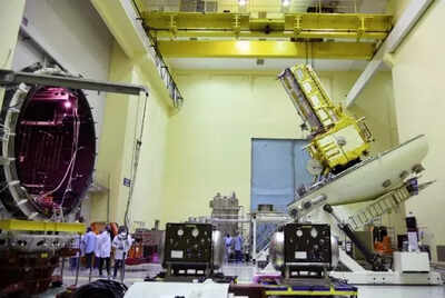
(Nisar) mission — has entered its last leg with launch expected by the end of July from India’s spaceport in Sriharikota. Nisar, which has been in the works for more than a decade, will cost around $1.5 billion, making it the most expensive satellite mission the world has executed so far. Isro chairman V Narayanan, in an exclusive with TOI said both the satellite and the launch vehicle are at the spaceport and a series of final reviews will get underway this week. The Earth-observing satellite, a first-of-its-kind collaboration between Nasa and Isro, carries an advanced radar system that will help protect communities by providing a dynamic, three-dimensional view of Earth in unprecedented detail and detecting the movement of land and ice surfaces down to the centimetre.“The preparations are in full swing. We will be carrying out extensive reviews before we are confident of announcing a final date, but as things stand we are targeting the end of July,” Narayanan said. Nisar will be the first radar of its kind in space to systematically map Earth, using two different radar frequencies — L-band developed by Nasa’s Jet Propulsion System (JPL) and S-band by Isro. SAR refers to a technique for producing fine-resolution images from a resolution-limited radar system.
Aside from the payload on the satellite, Narayanan reiterated that the satellite itself was built by Isro and that the launch will happen on an Indian launch vehicle, the GSLV-MK2.“In that sense, this partnership is different from what we’ve had in the past. Like I’ve told you earlier, strength respects only strength and in this mission the fact that we are equal partners shows how Isro and India have grown,” Narayanan said.“Nisar will use SAR to scan nearly all the planet’s land and ice surfaces twice every 12 days. Each system’s signal is sensitive to different sizes of features on Earth’s surface, and each specialises in measuring different attributes, such as moisture content, surface roughness, and motion,” Nasa said.The satellite will provide spatially and temporally consistent data for understanding changes in Earth’s ecosystems, ice mass, vegetation biomass, sea-level rise, groundwater and natural hazards including earthquakes, tsunamis, volcanoes and landslides. TOI first reported about Isro and Nasa working on a dual-radar satellite as early as in Nov 2013, and nearly a year later, On Sept 30, 2014, the two space agencies signed a formal partnership to collaborate on and launch Nisar.


.png)
.png)
.png)


 3 hours ago
5


 English (US) ·