

 1 hour ago
5
1 hour ago
5
ARTICLE AD BOX
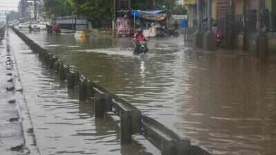
The roads in Narsingpur along the Delhi-Gurgaon Expressway was inundated after Gurgaon received 83mm of rainfall in 24 hours
Gurgaon: The city will likely see heavy showers till the weekend, the India Meteorological Department (IMD) said while issuing a yellow alert on Wednesday. Across the state too, there will be widespread rainfall till July 10, the weather department has predicted.IMD warned the active monsoon spell could trigger waterlogging, traffic snarls, flooding of low-lying areas, temporary disruption of civic services and damage to standing crops.It attributed the active weather to a well-marked low-pressure area over northwest Madhya Pradesh and adjoining southwest Uttar Pradesh, which continues to persist and is likely to move north-northwestwards over the next two to three days.
A western disturbance over the northern hills is also contributing to enhanced rainfall activity.For Gurgaon’s tehsil-level nowcast, the IMD predicted thunderstorms accompanied by lightning, moderate rainfall of 5-15 mm per hour and gusty winds of 30-40 kmph over Gurgaon, Sohna and adjoining areas. The nowcast, issued at 12.03pm on Wednesday, remained valid till 3.03pm.The department advised residents to avoid taking shelter under trees, stay away from water bodies, unplug electrical appliances during lightning and drive cautiously because of poor visibility and slippery roads.
According to the IMD’s district-wise forecast, rainfall is likely at most places (75-100% of weather stations) on Wednesday and Thursday, before easing (50-75%) on Friday. Rainfall activity is expected to weaken further over the weekend, with showers confined to a few places and no warning issued for the district from July 11 onwards.The alert comes after Gurgaon recorded 83mm (8.3cm) of rainfall in 24 hours till 8.30am on Wednesday, making it one of the wettest locations in Haryana. Rain continued through the day, with the IMD’s Gurgaon observatory recording another 37mm between 8.30am and 5.30pm.
The district administration, which compiles tehsil-wise data from 8am to 5pm, reported 32mm of rainfall in Gurgaon tehsil during the same period. According to the district administration, Kadipur and Harsaru received 33mm each, followed by Badshahpur (20mm), Farrukhnagar (18mm), Wazirabad (16mm), Sohna (10mm), Manesar (7.5mm) and Pataudi (4mm).The persistent rain also brought a sharp fall in temperatures.
IMD said the average maximum temperature across Haryana dropped by 4.7 degrees Celsius compared with Tuesday and was 5.2 degrees below normal. In Gurgaon, the maximum temperature settled at 29 degrees Celsius, 9 degrees below normal, while the Gurgaon AWS recorded an even lower 27.1 degrees Celsius. The city’s minimum temperature was 24.3 degrees Celsius, about 2.9 degrees lower than the previous day.
Sirsa remained the hottest place in the state with a maximum temperature of 36.2 degrees Celsius, highlighting the sharp contrast between the rain-soaked southern districts and the relatively drier western region.Independent weather forecaster Navdeep Dahiya said, “Radar imagery indicated moderate to heavy rain and thundershowers were likely across most parts of Delhi-NCR, including Gurgaon, over the next two to three hours, warning of fresh waterlogging at vulnerable locations.”IMD said the ongoing spell could result in flooding of roads and underpasses, poor visibility, slippery roads, longer travel time, temporary disruption of water and electricity supply and damage to standing and harvested crops. Farmers have been advised not to apply fertilisers or pesticides during the rain spell and to ensure proper drainage from fields, while residents have been urged to avoid waterlogged stretches and unnecessary travel during periods of intense rainfall.









 English (US) ·