ARTICLE AD BOX
India Today's analysis of satellite data reveals harrowing destruction in Dharali, Uttarkashi

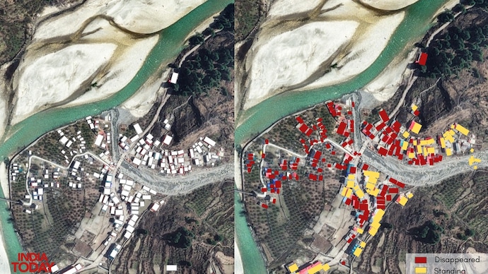
Visual analysis of post-disaster satellite imagery showed that the roofs of only 54 out of the roughly 182 buildings were still intact as of August 8.
At least 128 buildings in the mudslide-affected parts of the tourist village of Dharali in Uttarakhand’s Uttarkashi district have been either completely buried or swept away, India Today can confirm after analysing three sets of satellite data. 
An independent visual analysis of post-disaster satellite imagery by India Today’s Open-Source Intelligence (OSINT) team established that the roofs of only 54 out of the roughly 182 buildings were still intact as of Friday, August 8.
Our analysis covers only parts of Dharali village where the mudslide settled in a fan-shaped pattern – between the foothills of Dharali mountains and the Bhagirathi river.
The analysis of satellite imagery, combined with photos and videos recorded by Indian Army troops who reached the site immediately after the impact, establishes that the mudslide descended on the village in more than one wave.
At least four medium-to-large buildings — two of them popular hotels — were buried under several feet of debris in the later waves. These buildings can be seen in photos published by the Indian Army on August 5, but are absent in satellite imagery captured two days later.
Images also show that the Bhagirathi river’s flow was altered after the sheer volume and force of mud and rocks surged into it from the Kheer Gad stream.
CLOUDS OF UNCERTAINTY
Authorities and experts have been struggling to ascertain the exact extent of damage, largely due to the unavailability of clear satellite images because of prevailing cloud cover over the village and surrounding mountains.
The debris is spread over an area of 20 hectares, according to an ISRO assessment. The height of the debris column is estimated to be between 25 and 50 feet.
This is the first set of satellite images to provide a clear and definitive assessment of the destruction.
However, clear satellite imagery is still not available for the mountains above Dharali village, where the mudslide originated — leaving geographers and ecologists to speculate. Three theories have been floated regarding the cause of the mudslide.
DAUNTING RESCUE
Though a multi-agency rescue operation is underway in Dharali, specialised teams armed with cutting-edge equipment and heavy machinery needed to locate and rescue survivors trapped under the debris have struggled to reach the site due to road breaches and the collapse of a key bridge on National Highway-34, which connects Uttarkashi town to Dharali.
The Indian Army has deployed Chinook helicopters to transport power generators and earthmovers to the affected area.
At least 100 people, including nine Army personnel, are missing. More than 500 locals and visitors have been rescued.
Five people have been confirmed dead, as per official figures.
- Ends
Published On:
Aug 8, 2025


.png)
.png)
.png)


 4 hours ago
5


 English (US) ·