

.png)
.png)
.png)
.png)


 1 day ago
5
1 day ago
5
ARTICLE AD BOX
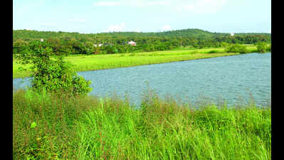
Panaji: Faced with depleting land use, state govt has recommended setting up a board to revive the khazan land. The board’s decision on land use will be final and will override the Regional Plan, ODPs and other land use policies, except the Goa Land Use Act of 1991, which will continue to apply to lands under agricultural tenancy, as these are also outside the scope of the TCP Act, 1974.The Khazan Land Management Plan (KMP) is meant to preserve all farmland and improve food security by growing more rice, vegetables, and fish locally. It suggests surveying the land for cultivation or types of cultivation on existing active khazans and land left fallow.As per the recommendations, the khazan board or any similar agency govt chooses to set up, will manage all areas as zoned in four categories: K1 — low salinity, good for vegetables and second-season rice; K2 — moderate salinity, can grow salt-tolerant rice; K3 — high salinity, suitable for traditional rice, salt, and fish farming; and KH — highly degraded, mostly abandoned with mangrove growth.The department of environment and climate change will officially notify the formation of the khazan board and act as its secretariat. “Once formed, the board will prepare the detailed KMP based on the CRZ 2011 notification and the approved Coastal Zone Management Plan (CZMP). The department will define the board’s legal powers, structure, and responsibilities within six months. KMP will be reviewed and updated as per the CZMP and CRZ notification in force from time to time,” the recommendations said.
The plan recommends conducting comprehensive soil mapping and salinity profiling across different khazan zones to assess soil health and productivity potential for determining suitable crop and aquaculture zones. Under the action plan, it is recommended to implement periodic water quality monitoring to measure parameters like salinity, pH, dissolved oxygen, nutrients, and heavy metal contamination to ensure safe aquaculture and agriculture practices.The aim is to promote desalination techniques, controlled tidal flushing, and freshwater irrigation to maintain soil fertility and improve agricultural productivity. “It will also utilise bio-remediation techniques such as microbial consortia and organic amendments to enhance soil and water quality in consultation with ICAR and other institutes,” the plan said.A detailed study-cum-mapping is needed to understand the total khazan land and ownership, the status of sluice gates, salt pans, and bunds, functional tenants’ associations and their activities over the past five years, auction details and earnings from fisheries, the total number of internal water bodies for the revival of khazan land, the plan said.
Understanding the extent and distribution of salinity is crucial for the revival action plans for both sustainable agriculture and aquaculture.“This data can be additionally verified as per ground truthing, including its status if degraded. Degraded lands which cannot be restored should be identified,” the plan said.To undertake GIS-based mapping, a pilot study for the identification of khazan lands using UAV-based LiDAR technology by involving local communities is recommended. Classification can be based on salinity levels, acidity levels, water retention capacity, and existing land use patterns, highly productive zones, degraded areas, and restoration sites, the plan said.


 English (US) ·