 1 hour ago
3
1 hour ago
3
ARTICLE AD BOX
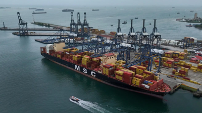
The widening war in the Middle East is beginning to disrupt one of the world’s most vital maritime corridors, with cargo ships, oil tankers and other commercial vessels struggling to navigate waters around the Gulf.
As fighting between Iran, Israel and the United States intensifies, the ripple effects are spreading beyond battlefields to global trade routes that carry a large share of the world’s energy and goods.Since the conflict erupted on February 28, attacks, drone interceptions and electronic warfare have created an increasingly hostile environment for maritime traffic in the Gulf and the Gulf of Oman. Shipping companies and analysts say the war has not only raised fears of physical attacks on vessels but has also triggered widespread disruption to satellite navigation systems used by ships.For shipping companies, the result is a rapidly changing risk environment. The Strait of Hormuz, through which roughly a fifth of the world’s oil and gas supply passes, has already come under pressure as energy facilities and infrastructure across the Gulf become targets.
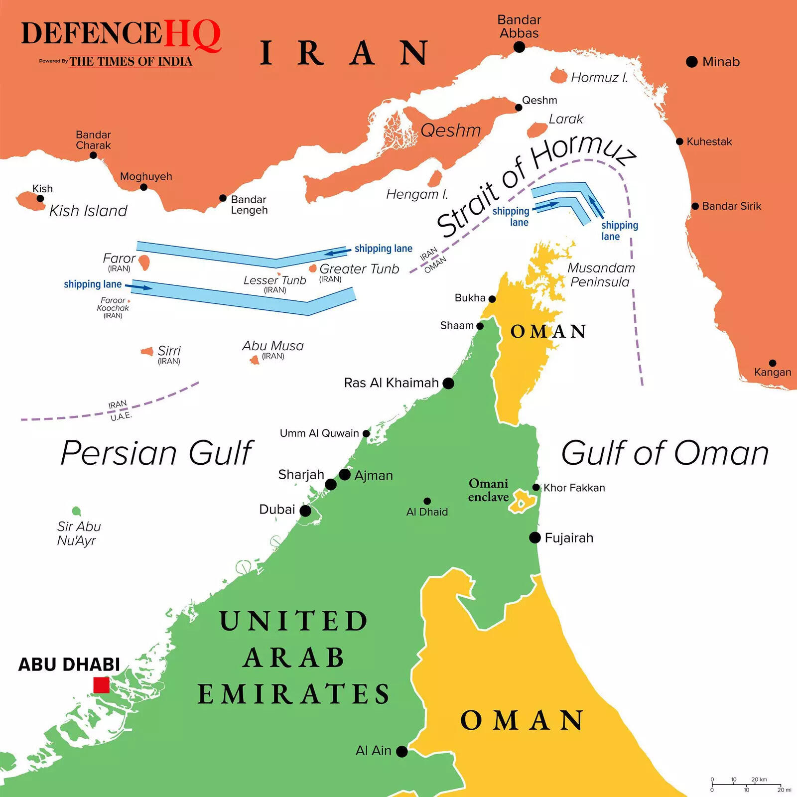
One of the most significant problems has been the jamming of GPS signals across large parts of the region. According to maritime analysts, around 1,000 vessels operating in the Gulf and the Gulf of Oman have experienced navigation disruptions since the start of the conflict.
That number represents roughly half of the ships currently operating in those waters, many of them clustered off the coasts of the United Arab Emirates and Oman.The disruptions come as the war continues to widen. Israel has intensified strikes in Lebanon and Iran, while Tehran has launched drones and missiles at targets across Gulf states including the UAE, Saudi Arabia and Kuwait. With air defence systems intercepting projectiles across the region and military forces deploying electronic warfare measures, the maritime environment has become increasingly unpredictable for commercial shipping.
GPS disruptions leave ships struggling to navigate
Modern cargo ships rely heavily on satellite navigation systems to determine their exact position at sea. However, many vessels still depend on older GPS technology that is far less resilient to interference.Unlike modern smartphones, which can receive signals from several global satellite networks such as the American GPS system, Europe’s Galileo, Russia’s GLONASS and China’s BeiDou, many ships only rely on a single older civilian GPS signal known as the L1 C/A frequency.
This signal has been in use since the early 1990s and is relatively easy to disrupt.Experts say this technical limitation makes ships particularly vulnerable when electronic warfare systems jam navigation signals. By transmitting stronger signals on the same frequency, jammers can effectively drown out legitimate GPS transmissions, preventing ships from determining their precise location.The disruption can last seconds or continue for extended periods, leaving captains uncertain about their position in some of the world’s busiest shipping lanes.
In extreme cases, vessels may temporarily lose the ability to navigate electronically, forcing crews to rely on older methods such as radar and visual landmarks.For large cargo vessels that can stretch hundreds of metres in length, navigating crowded waters without accurate positioning systems presents serious operational risks.
Spoofing and electronic warfare complicate maritime traffic
Beyond simple signal jamming, a more advanced form of interference known as “spoofing” is also raising concern among maritime experts.Spoofing manipulates a ship’s Automatic Identification System (AIS), the universal radio system that vessels use to broadcast their identity, location and destination every second. By feeding false data into the system, attackers can make a ship appear to be somewhere entirely different from its real position.In some cases, affected vessels may appear on tracking maps as being located on land or inside another country’s territory.
This creates confusion not only for ship crews but also for maritime authorities monitoring traffic in busy waterways.The problem is compounded by the fact that GPS signals are not only used for navigation. On modern vessels, they also synchronise onboard clocks, radar systems and speed logs. When signals are disrupted, multiple ship systems can be affected simultaneously.
War-driven defences are disrupting global shipping routes
Much of the interference appears to be linked to defensive measures deployed by countries trying to protect themselves from drone and missile attacks.Gulf states have reportedly used GPS jamming systems along their coastlines to interfere with satellite-guided drones launched by Iran. These defensive measures can create large zones where navigation signals become unreliable, affecting civilian infrastructure and commercial shipping as well.Similar tactics have been used in past conflicts. Israel deployed GPS disruption measures extensively during earlier regional tensions, while Iran has also used electronic warfare capabilities during previous confrontations.(With inputs from AFP)


 English (US) ·