
.png)
.png)
.png)
.png)


 4 hours ago
1
4 hours ago
1
ARTICLE AD BOX
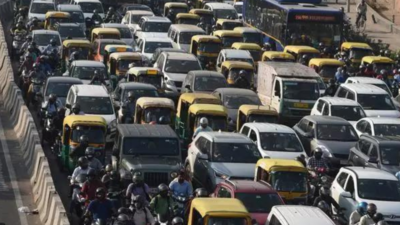
NEW DELHI: To untangle some of Delhi's worst traffic points, the Public Works Department has invited consultants to prepare feasibility studies for flyovers, underpasses, or elevated corridors across eight previously proposed major stretches of the city.
Covering nearly 47km, these will be part of an integrated transit corridor development plan.Each corridor has been mapped with its traffic signal counts, available right of way (ROW), and causes of congestion. The aim is straightforward: resolve chronic congestion and improve overall connectivity on stretches that serve as critical commuter and freight routes.

One of the more significant segments is a 7km length of Deshbandhu Gupta Road opposite Paharganj up to Ajmeri Gate.
With nearly seven signals, the road is heavily congested throughout the day. A feasibility study for a flyover or underpass has been proposed.A bit further, the Shadipur Depot stretch too is in the plans. It includes four major intersections, with a ROW of 40 metres at Mathura Road and 30.5m at Goswami Girdhari Marg.Similarly, at the ITO intersection — one of Delhi's busiest nodes —a 4km integrated corridor is proposed.
Nearly five signals slow down traffic on Vikas Marg, Deendayal Upadhyaya Marg and Bahadur Shah Zafar Marg. ITO's criticality is heightened by the concentration of govt offices in the area, including Institute of Chartered Accountants of India, Income Tax Office, PWD headquarters and some media houses.On the city's eastern edge, the plan envisions a 6km elevated corridor from Nanaksar Gurdwara T-point to the Delhi-UP border at Tronica City.
This stretch runs along Yamuna Pushta and service roads, with a ROW of about 19m. Challenges here include restrictions due to environmental rules on the Yamuna floodplain, trees lining both sides and utility obstacles such as DJB pipelines and large manholes.In west Delhi, a 2.2km elevated corridor has been proposed for from Zakhira crossing to Karampura flyover on Shivaji Marg. The stretch has a 60m ROW with four major intersections, including a signalised point on Milan Cinema Marg.Near Indira Gandhi International Airport, the NSG intersection in front of Terminal 1 has been shortlisted to get a 2km flyover or underpass to decongest the busy four-arm junction. In northwest Delhi, a railway overbridge is being considered near Sukhi Nahar in Kirari. While the ROW is 25m on the Nangloi-Rohtak side, it narrows to a traffic-choking 12m on the Rohini Sector 20-21 side.An ambitious redevelopment will be a 20km corridor from Najafgarh (Phirni Road) to NH-48 near Kapashera, including a part of the Old Delhi-Gurgaon Road from UER-II to Kapashera border.
This section features 15 traffic signals, several minor road openings and areas of severe congestion, particularly at Samalkha village (due to schools, markets, and farmhouses) and Kapashera Crossing.According to PWD, the detailed project report will cover design, cost estimates, economic and financial viability, environmental and social feasibility, as well as required approvals. Consultants will be responsible for ensuring value engineering, road safety audits, and compliance with approvals from bodies such as road engineering authority UTTIPEC, Delhi Urban Arts Committee, Archaeological Survey of India, Delhi Fire Service and the forest department.The consultant's job will go beyond traffic counts and origin-destination surveys to include mapping land ownership, assessing encroachments and preparing layouts for acquisition. GPS-based tree counts will be conducted in consultation with the forest department to plan transplantation or felling.On the design side, the scope spans roads, footpaths, bus bays, utility ducts, stormwater and rainwater harvesting systems, with traffic diversion plans and road markings aligned to Indian Road Congress norms.
Pedestrian safety features — kerb ramps, bridges, railings and crash barriers — will be prioritised.Environmental safeguards will include noise barriers, drainage, flood management and ecological studies, while road safety will be backed by signage, signals, gantries and a safety audit. A baseline socio-economic survey and stakeholder consultations will guide the design to minimise displacement.


 English (US) ·