 4 hours ago
3
4 hours ago
3
ARTICLE AD BOX
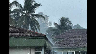
Panaji: Post-monsoon showers drenched parts of Goa on Thursday as thunderstorms swept the coastal state, bringing relief from the humidity even after the southwest monsoon’s withdrawal from the region.
The sudden change in weather conditions brought down the day temperatures across Goa.According to the India Meteorological Department (IMD), Panaji recorded a maximum temperature of 31.2°C, about 1.5°C below normal for this time of the year. The IMD has extended the yellow alert for both North and South Goa districts till Oct 26, warning of thunderstorms with lightning and winds reaching 30–40 kmph, gusting up to 50kmph.The forecast also indicates heavy rainfall at isolated places and moderate to heavy showers over most parts of the state.
Despite the rain, IMD officials said no major change in temperature is expected over the next 48 hours, with maximum and minimum temperatures likely to hover around 33°C and 25°C, respectively.The IMD’s latest bulletin reported a depression over the southeast Arabian Sea moving northeast at 5kmph over the past six hours. As of Thursday, it was centred approximately 560km west-southwest of Aminidivi (Lakshadweep) and 910km southwest of Panaji.
It is expected to move towards the east-central Arabian Sea over the next 24 hours.A distant cautionary signal (DC-I) has been hoisted at all ports from Dahanu to Mormugao along the Maharashtra-Goa coastline, advising ships and port authorities to stay alert to changing sea conditions.Squally weather with winds of 35–45kmph, gusting up to 55kmph, is likely to prevail along and off the South Konkan-Goa coast from Oct 24 to 27 and the North Konkan coast from Oct 25 to 27. The Indian National Centre for Ocean Information Services (INCOIS) reported no high-wave warning for Goa as of Thursday. Sea conditions will remain rough to very rough over the southeast and adjoining east-central Arabian Sea till Oct 25.
Fishermen have been strictly advised not to venture into the sea along the above-mentioned coasts until Oct 25.


 English (US) ·